Wednesday
Jul182012
Mississippi Messgaes - July, 2012
 David Tinjum
The latest news from Friends of the Mississippi River:
Preserve.Revitalize.Connect.
Gold Medal Park to Be Preserved for 50 Years
Letter to the Editor - Ideas for the Minneapolis Riverfront
The latest news from Friends of the Mississippi River:
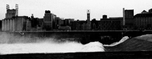
From KARE 11:
The raging waters of the Mississippi River have forced the cancellation of the season's first Twin Cities River Rats Waterski Show on Thursday night.
Earlier this week, the Army Corp of Engineers closed the Mississippi River to commercial and recreational traffic due to high water flow.
The 'Twin Cities River Rats' perform every Thursday night during the spring and summer for free near Broadway Avenue in Minneapolis.
Dave Tombers, the President of the Twin Cities River Rats, said this is the first time he can remember that they had to cancel the show for high water.
The next show is scheduled for June 7th.
http://www.kare11.com/news/article/977879/396/High-water-sinks-River-Rats-waterski-show
Awesome documentary on the Mississippi River and Minneapolis...
From KSTP:
Asian carp are beginning their invasion in Minnesota, with four caught in the last year - including one just last week.
The fish may just be showing up here, but they're a big problem in central Illinois near Peoria. Residents say fishing isn't what it used to be because the Asian carp have cut down on other fish.
Plus, the size of the Asian carp means they can do damage to boats and hurt people. A study there found 33 percent of boats have been damaged by carp and 47 of boaters have been hit by flying carp.
Betty DeFord, who runs The Boat Tavern, says her boating customers aren't showing up.
"They don't want to get bloodied and slimed with the stupid fish," DeFord says. "They can bruise you, knock you out of your boat."
This year the Illinois legislature even considered a bill allowing boaters to shoot the Asian carp.
http://kstp.com/article/stories/S2598503.shtml

Recents posts from the River Talk Blog from the U of M:
River-City Connection: Poorly Understood? Too Complex to Understand or Model
I have been posting a number of articles and links on our River Portal microblog (Yes, we have one. And yes, you should read it. It’s here. Now go and read it. Good. You’re back? Now where was I?) about sustainability in cities, about the importance of public art in cities, about urban green infrastructure. What’s all that got to do with rivers?
Well, everything, I think. Here are some ideas, call them axioms, propositions, definitions, or what have you.
St. Anthony Falls Needs YOU
Well, maybe the Falls themselves don’t need you–water seems to flow over them ok, per gravity and basic hydrology. But the elements of Minneapolis around the Falls Do need your help.
The Central Minneapolis Riverfront is poised to be the engine driving the city into the 21st Century because the City, its citizens, the Minneapolis Park Board and a host of other individuals and organizations have concentrated on the district for the past 40 years. Today, as a result of that effort, $400 million of public investment has created $1.3 billion in private contributions to a place that is arguably a World Heritage-caliber site.
Following the vision and the success of 2009′s landmark study Power of the Falls, the city’s Community Planning and Economic Development Department has invited public comment on a new set of design guidelines for the Central Riverfront. To read the document and make your comments, go here.

From the Star Tribune:
A popular leisure cruise will no longer travel through locks beside the Stone Arch Bridge as part of a city effort to ward off Asian carp.
The Minneapolis Park Board voted Wednesday night to stop Paradise Cruises from using the Upper St. Anthony Falls Lock and Dam. The change is part of an effort to scale down use of the lock, which may be eventually closed altogether to prevent Asian carp from reaching northern Minnesota.
| April 2012 | |
 |
|
 |
|
|
|
|
|
|
|
||
Almost a year after the tornado hit North Minneapolis, there’s one hopeful sign. The blue herons, whose population was devastated by the storm, have returned to an island in the Mississippi River.
 News Release
Minneapolis Park and Recreation Board to redefine “City of Lakes” with RiverFirst
Sweeping vision for Mississippi riverfront parks and public space will create largest expansion of nationally recognized park system in 100 years
Minneapolis, Minn., March 29, 2012 – The Mississippi River shapes a continent, shaped a nation and defines the cities along its course, including here in the “City of Lakes,” where 5.5 miles of the Mississippi riverfront will soon host the largest expansion of park and public space since the award-winning park system in Minneapolis was created over 100 years ago. The Minneapolis Park and Recreation Board approved, on March 14, RiverFirst: A Park Design Proposal and Implementation Plan for the Minneapolis Upper Riverfront. With the adoption of RiverFirst, the Minneapolis Park Board sets in motion a five-year initiative to create several miles of new Mississippi riverfront walking and biking trails, three new multifunctional parks and multiple local and regional connections to one of the four great rivers of the world and “America’s fourth coast.”
RiverFirst is the outcome of the 2011 Minneapolis Riverfront Development Initiative (MR|DI), a nine-month community-based vetting of the winning landscape and urban design concept submitted by the RiverFirst Design Team of Tom Leader Studio and Kennedy & Violich Architecture to the 2010-11 Minneapolis Riverfront Design Competition. More than 60 agency and community partners, along with a broad spectrum of community members, were directly involved in the MR|DI. The RiverFirst Design Team included New York-based economic development consultants HR&A Advisors, which created the RiverFirst implementation plan, and Groundwork City Building, which managed the project.
“This is a tremendously exciting time for the Minneapolis Park Board, the city and residents of North and Northeast Minneapolis, in particular,” says John Erwin, President of the nine-member board of elected Commissioners governing the independent agency. “We are known as the ‘City of Lakes,’ but we also recognize that the Mississippi River is the birthplace of our city and has been neglected as a citywide natural amenity. Under the RiverFirst initiative, the Park Board will work with our partners to bring to life a vision that will transform the Upper Riverfront for residents of Minneapolis, the region and the state. We recognize this project will not only add recreational amenities, but will also be an economic catalyst for the entire area, and dramatically increase bird and fish habitat along an important natural flyway. Taken together, this project is a win for everyone.”
A “multi-modal” vision serving generations to come
The 6,725-acre Minneapolis park system is renowned for more than 100 miles of parkways, trails and greenways that interlink regional park destinations. Together with the more than 150 neighborhood parks, these regional parks attract more than 20 million visits annually, especially to multifunctional natural, recreational and entertainment destinations, such as the Chain of Lakes.
The RiverFirst vision builds on this dynamic legacy with the creation of riverfront regional parks connected by a sophisticated network of trails that balances infrastructure with ecology. RiverFirst fills the gap in the Mississippi River parks and trails system and contributes significantly to improved water quality of the river, completes a critical connection to the larger Minneapolis “Grand Rounds” and links into existing corridor initiatives taking place on both sides of the river.
Furthermore, RiverFirst creates a healthy community network and opportunities for economic development, by tying into the expansive regional parks and trails system managed by the Three Rivers Park District and the Metropolitan Council.
The RiverFirst Design Team was guided by the dynamics of the river and the RiverFirst design is infused with essential infrastructure such as stormwater treatment, flood storage, energy generation and food production – practices that derive multiple public benefits from a single investment and will spur development, retain and attract talented people, and enrich the city’s culture – necessary ingredients for a 21st century river city.
“There are 21st century challenges that are global in nature and local in impact. RiverFirst considers how the Minneapolis park system can protect the national ecological heritage of the Mississippi River, foster community health, support economic opportunity and prepare Minneapolis with resilient and sustainable eco-infrastructure for generations to come,” says Tom Leader, Principal of the RiverFirst Design Team and Founder of Tom Leader Studio. The Design Team considered multiple approaches – loops, moisture gradients, urban ecology, mobility, green networks and water – when shaping the RiverFirst vision. Adds Sheila Kennedy, Principal of the RiverFirst Design Team and Partner in Kennedy & Violich Architecture, “RiverFirst integrates these approaches to cultivate a ‘blue and green’ – river-first and sustainable – way of life in Minneapolis, nurtured by responsive, multi-modal public places around which residents thrive and businesses prosper.”
Given its ambition, full realization of the RiverFirst vision will likely take 20 years. Through the MR|DI, the RiverFirst Design Team developed a Strategic Implementation Plan for five phase one priority projects to meet the city’s needs today and build momentum for overall completion of the RiverFirst vision over time. The five priority projects will be pursued simultaneously, with participation from multiple agencies and stakeholders: riverfront trail system and knot bridges; the Scherer Park District; Northside Wetlands and Downtown Gateway parks; new greenways on both sides and leading to the river; and floating islands.
Three additional projects are featured in the long-term RiverFirst vision: A mile-long land bridge covering Interstate 94, Northeast Riverfront Park, and Spirit Island. There is potential in the short- and long-term for additional projects to fit under the RiverFirst standard. Such projects would likely have to meet a number of criteria, including being within, or a critical connection to, the RiverFirst geographic area; creating public space with multiple purposes or uses, such as being an attraction, or providing transportation or economic development opportunities; and integrating with the area ecologically, culturally and with the built environment.
Five-year priority projects are underway
With the adoption of the RiverFirst vision, the Minneapolis Park Board begins a series of 2012 design and planning next steps for projects to be built beginning in 2013:
Over five years, the RiverFirst framework calls for completion of five priority projects at an estimated cost of $174M from a mix of public and private funding for both capital projects and operating costs. Some of the potential sources are outlined in the Implementation Guide, found in the RiverFirst proposal and executive summary.
The road to RiverFirst
In April 2011, the Minneapolis Park Board established the Minneapolis Riverfront Development Initiative as a special project to carry through the promise of connecting people from near and far with new multifunctional Upper Riverfront parks along “America’s fourth coast.” The MR|DI was charged with transforming RiverFirst from a visionary concept to a workable plan for short- and long-term parks-based development.
Beginning in June 2011, the MR|DI carried out a summer-long community engagement process that included: a community input survey taken by more than 600 people; promotion and participation in more than 30 community events throughout Minneapolis; three additional public meetings held in association with the City of Minneapolis and the Minneapolis Riverfront Partnership; more than 40 presentations and meetings with neighborhood associations, community-based non-profit organizations, agencies and other stakeholder groups; and the debut of “River Is,” a figurative gathering of people’s thoughts about the Mississippi today and for the future.
About the Minneapolis Park and Recreation Board
With 182 park properties totaling nearly 6,732 acres of land and water, the Minneapolis Park and Recreation Board provides places and recreation opportunities for all people to gather, celebrate, contemplate, and engage in activities that promote health, well-being, community, and the environment. Each year, approximately 18 million visits are made to the nationally acclaimed Minneapolis park system. Its urban forests, natural areas and waters endure and captivate. Its Grand Rounds National Scenic Byway, neighborhood parks, recreation centers and diversified programming have made the Minneapolis park system an important component of what makes Minneapolis a great place to live, play and work. To learn more about the Minneapolis Park and Recreation Board, visit www.minneapolisparks.org.
###
--
Janette Law
RiverFirst and MR|DI Public Relations Manager
dir 612-929-0939 mbl 612-306-4430
Visit our blog

Mill City Times | 35W Bridge Memorial | Mill District Block Party | Mill City Media
