Restoration of Hall’s Island Along Northeast Minneapolis Riverfront Begins in November
 Kim Eslinger
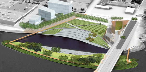 An illustration showing the completed plans for Hall's Island. The island will remain off-limits to people during this first phase to allow plants and wildlife habitat to establish.
Work to carve back channel, build out island will take place over next 6-8 months at Scherer site
The Minneapolis Park and Recreation Board (MPRB) announced construction begins in November on a project that will restore Hall's Island along the Northeast Minneapolis riverfront. Work will be based out of the Scherer site, an 11-acre piece of land directly north of the Plymouth Avenue Bridge that was purchased by the MPRB in 2010.
Restoring Hall’s Island will be an important milestone in the long-term vision laid out for Upper Riverfront in RiverFirst and Above the Falls Master Plan. These plans call for the incremental transformation of more than 11 miles of largely inaccessible shoreline degraded through decades of industrial use into an ecologically valuable network of parkland and trails.
Work to construct the island will include expanding the existing shoreline into the river and carving out a back channel through the Scherer site to form the island. This phase of the project is expected to last up to eight months.
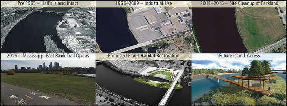 An aerial image collage showing past and future land use at the Hall's Island / Scherer site
Hall's Island History and Upcoming Work
The island shows up on the earliest known survey (1895) of the Mississippi River through Minneapolis. The City of Minneapolis operated a bath house on the island from 1905 to 1926. Hall’s Island was sold to Scherer Bros Lumber Co in 1963 and Scherer Bros filled the channel and connected the island to shore in 1966 to expand mill operations.
The MPRB purchased the Scherer site in 2010. From 2011 to 2013, a plan to restore the island and build a park on the adjacent shoreline was created and approved as part of RiverFirst and Above the Falls Master Plan. In 2013, the Minnesota State Legislature authorized a six-year window to restore Hall’s Island.
Since then, the MPRB and consultants conducted extensive environmental investigation and advanced design work to get the project permitted through the US Army Corps of Engineers, Minnesota Department of Natural Resources and Minnesota Pollution Control Agency.
Once restored, Hall’s Island will stretch from the northern edge of the Scherer site, extend south underneath the Plymouth Avenue Bridge and include the Boom Island Lighthouse at its southern tip. It will feature a sandy habitat beach (off-limits to people), rock ledges, basking logs, shrubs, plants, trees and prairie grasses.
The open water back channel will range from approximately 120 to 150 feet wide, with an average depth of approximately six feet during normal flow conditions. Materials placed in the back channel will provide high-quality habitat for native mussels.
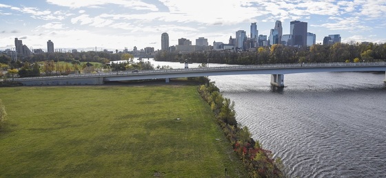 Aerial photo of the Scherer site before construction begins. Over winter workers will use clean fill to extend the shoreline into the river & carve a back channel through the pictured land.
Future Phases and Construction Impacts
Future phases of park development will include two pedestrian bridges connecting to the island from the Scherer site and a third bridge connecting to Boom Island Park, an elevated boardwalk on the island with observation platforms, and expanded riverfront trails across the mainland.
Construction is scheduled to start in November. Initial work will include soil remediation and site grading. The Mississippi East Bank Trail will close between Boom Island Park and Sheridan Memorial Park during most of the construction period and reopen next summer, when the project is scheduled to wrap up.
The trail detour reroutes pedestrians and bicyclists to Marshall Street NE between 8th Avenue NE and 13th Avenue NE.
To learn more about this project and others, visit www.minneapolisparks.org/planning.
